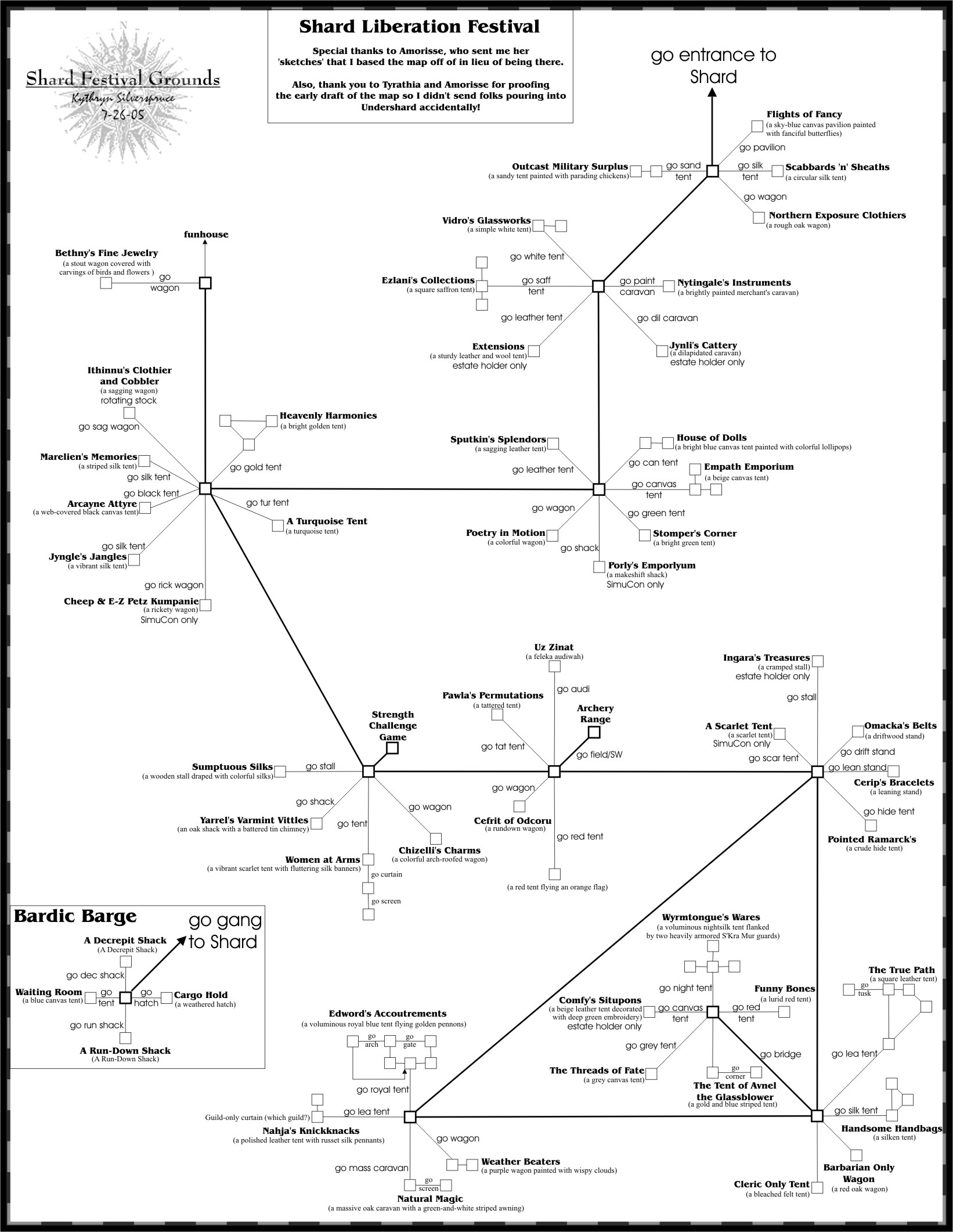
|
 Notes Notes
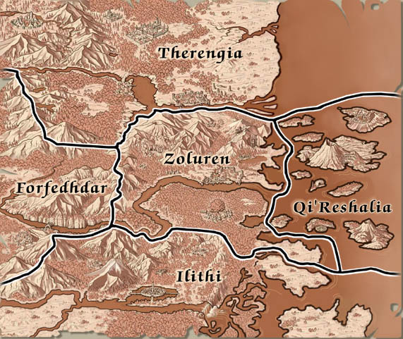
Overview Maps
- Overview of Kythryn's Map Numbers - updated 8-22
- Overview Table: as a companion to the the above overview graphic, this page has an itemized table that lists all the cities and waypoints and has crosslinks to the appropriate map pages - updated 8-22
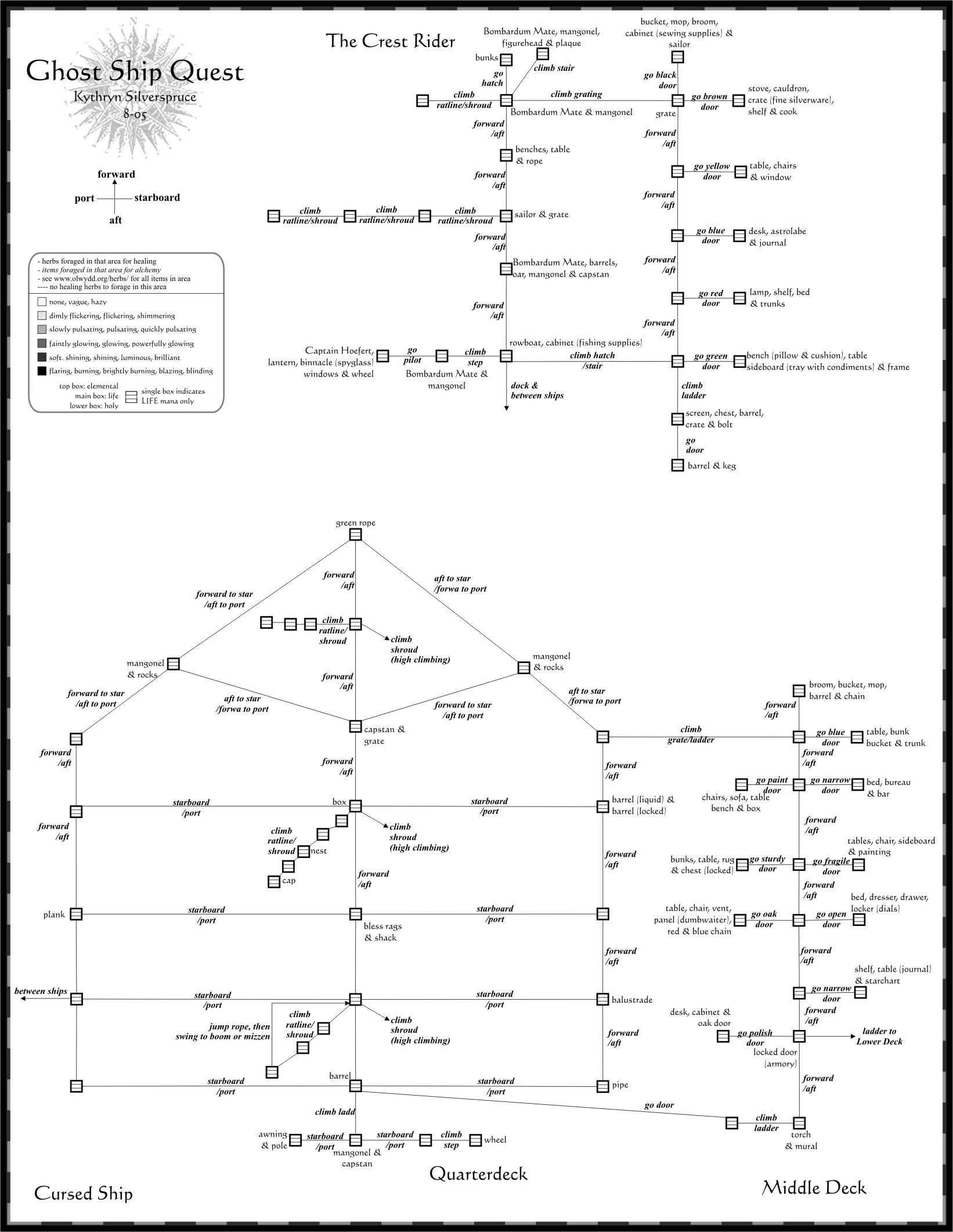
- Jadewater Mansion & Aldamus House, map00: Character starting areas in Crossing & Riverhaven - updated 4-22
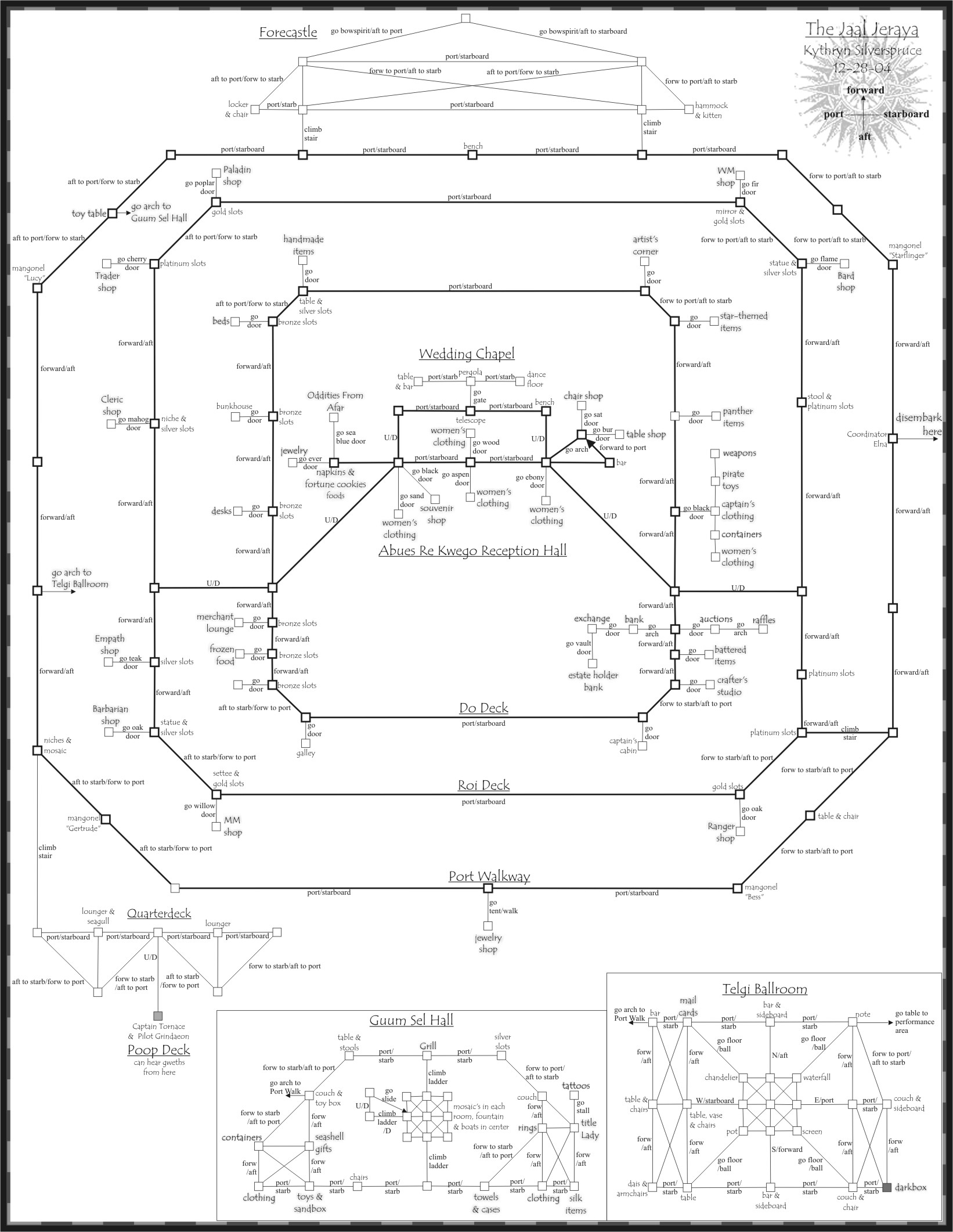
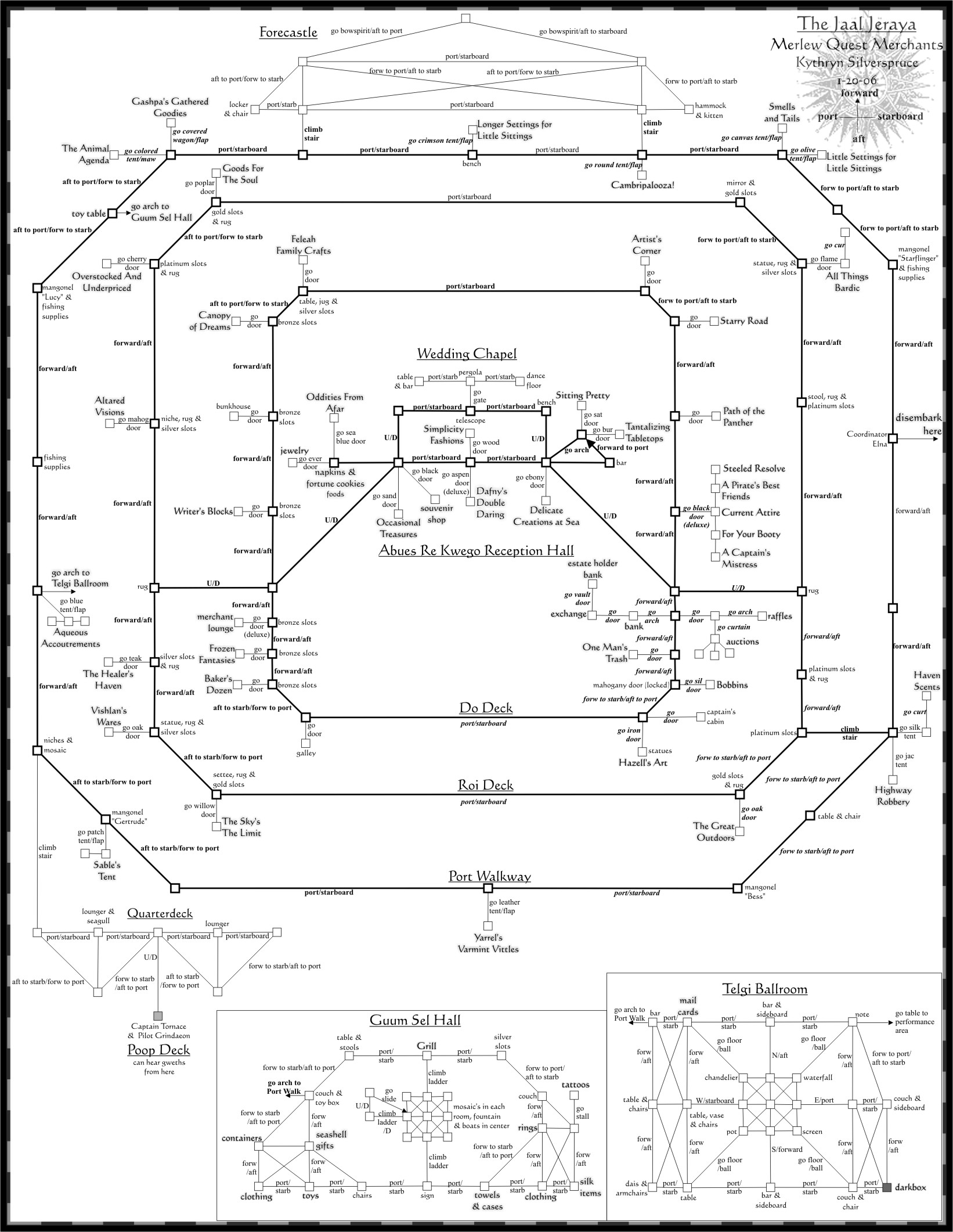
- Ship Maps, ShipMap: Maps of all public transportation vessels in Qi'Reshalia - updated 12-19
- Simutronics Overview - 2015 version of Elanthian Overview map
Therengia Maps (P2)
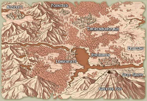
- Official Therengia rendered map from the Simu web site - Therengia
- Muspar'i, map01: City of Muspar'i - updated 1-22
- Muspar'i Interiors, map02: Muspar'i interiors - Temples, Inns, Guilds & World's End hunting area - updated 8-20
- Velakan Trade Route, map03: Velaka Desert, VTR, Migen'hhs Pat'shhry, Salt Gleaner Road & Lake Ratamipak - updated 10-20
- Hvaral, map04: Heru Taipa (Sand Clan/Haizen Cugis), Oasis, Velaka Desert & Hvaral - updated 10-20
- Ker'Leor, map05: Arnshal Road, Zengmodaleth, Fornsted & Ker'Leor - updated 10-20
- Theren, map06: Theren, Theren Keep & Breech Tunnels - updated 8-22
- Theren Interiors, map07: Theren Interiors - Trigomas Residence, Ibec Hall, Gealeranendae College & Market - updated 8-22
- El’Bains & North Road, map08: North Road & North Mistwood Forest El'Bains Stop & Kweld Andu - updated 1-22
- Langenfirth, map09: Langenfirth, Gwenalion Fens & the barges - updated 1-22
- Siksraja, map10: Siksraja & Ala - updated 1-22
- Mistwood Forest , map11: North & South Mistwood Forest - updated 8-22
- Rossman’s Landing, map12: Rossman’s Landing & Rossgallan Keep - updated 1-22
- Dunshade, Riverhaven N & W gates, map13: Dunshade Manor, Riverhaven West Gate & West Gate Wilds, Pine Woods housing, North Piedmont housing & Riverhaven North gate - updated 2-22
- Riverhaven, map14: The city of Riverhaven, UnderWharf & the ferries - updated 4-22
- Riverhaven Interiors, map15: Riverhaven interiors - Guilds, Crafting Halls, Inns, Town Hall & Trader Market - updated 4-22
- Zaulfung, map16: Riverhaven East gate, Pejek Bog & Zaulfung - updated 9-09 (update in progress 1-25)
- Throne City, map17: Throne City, Throne City hunting & barges - updated 2-10
- NTR & Gate of Souls, map18: NTR, Stone Road and Marsh, Skeleton's Crook and Gate of Souls - updated 7-13
- Sicle Grove & Greater Fist, map19: Sicle Grove, Greater Fist volcano path - updated 3-10
- Restricted Access Areas in Therengia, TherenMisc01: Estate Holder, Guild, Citizen & Other restricted areas in Therengia. This is a supplemental map to the set and may contain spoilers. - updated 8-20
- Restricted Access Areas in Therengia, TherenMisc02: Estate Holder, Guild, Citizen & Other restricted areas in Therengia. This is a supplemental map to the set and may contain spoilers. - updated 4-22
- Therengia .zip file, TherenZip: Map01-Map19 & the TherenMisc supplements- updated 8-22
Zoluren Maps (P1)
- Official Zoluren rendered map from the Simu web site - Zoluren
- NTR, map20: NTR, Silverwater Mines, Gazit Lair & Paper Mill - updated 7-11
- Dirge, map21: Dirge, Wicked Burrow Mine & Ossaury Caverns - updated 3-20
- Wilderness, map22: NTR, Wilderness & Thicket Hunting, Dense Copse, Dilapidated Cabin - updated 3-17
- Stone Clan, map23: NTR, Sorrow's Reach & Lariocott Brach (Stone Clan) - updated 7-13
- Kaerna Village & Arthe Dale, map24: NTR, Kaerna Village & Arthe Dale - updated 9-18
- Crossing NE Gate, map26: NTR, Beaerholt's, the Vineyards, DiSilveron Manor, Hilltop Cemetery & NE Wilds - updated 1-20
- Crossing North Gate, map27: Crossing North gate, NorthWall Trail, Royal Zoluren Mews & Brambles - updated 1-13
- Crossing Near West Gate, map28: Crossing near West gate, Temple Hill, Mycthengelde, Laakvor, Forisaad & the Siergelde's - updated 1-13
- Crossing far West Gate, map29: Crossing far West gate, Hunting Preserve, Willow Tree Marsh & Tiger Clan - updated 1-13
- Crossing very far West Gate, map30: Crossing very far West gate, Rocky Outcrop, Knife and Wolf Clans - updated 1-13
- Crossing, map32: City of The Crossing - updated 7-13
- Crossing Temple, map33: Crossing Temple - updated 1-13
- Crossing Temple Grounds & Escape Tunnels, map34: Crossing Temple Grounds, Watchtowers & Escape Tunnels - updated 1-13
- Crossing Interiors, map35: Crossing interiors – Guilds, Orders & Crafting Society Buildings - updated 7-13
- Crossing Interiors, map36: Crossing interiors – Raven’s Court, Town Hall, Market Plaza, the Inn's of Crossing & misc. interiors - updated 1-13
- Crossing-city Hunting & Housing, map37: Willow Walk, Fayl'Shar Court/Goldenstone Square, Smithy Lane/Crofton Walk, Midton Circle, apartments, Strand housing, Crossing Sewers, Shipyard & Warehouses - updated 7-13
- Middens & Lost Crossing, map38: Middens, Lost Crossing, Ulf'Hara Keep - updated 1-13
- STR, map40: Silverclaw Hub, STR, Forest of Night, Chelsea Overlook & the ferries - updated 5-18
- Leth Deriel, map41: Leth Deriel & Sana'ati Dyaus - updated 3-10
- Bosque Deriel & Acenamacra, map42: Bosque Deriel, Boggy Marsh and Eik Woods & Acenamacra Village - updated 9-13
- Osh. Manor, map43: STR, Tamsine's Rest & Oshu'erhhsk Manor - updated 5-18
- The Gash, map44: STR, The Gash, The Frozen Heavens & the gondola - updated 9-13
- Ilaya Taipa, map45: Old Crank's Road, city of Ilaya Taipa - updated 2-15
- Restricted Access areas in Zoluren, ZolMisc01: Estate Holder, Guild, Citizen & Other restricted areas in Zoluren. This is a supplemental map to the set and may contain spoilers. - updated 5-18
- Restricted Access areas in Zoluren, ZolMisc02: Estate Holder, Guild, Citizen & Other restricted areas in Zoluren. This is a supplemental map to the set and may contain spoilers. - updated 5-18
- Restricted Access areas in Zoluren, ZolMisc03: Estate Holder, Guild, Citizen & Other restricted areas in Zoluren. This is a supplemental map to the set and may contain spoilers. - updated 5-18
- Zoluren .zip file, ZolZip: Map15-Map45 & the ZolMisc supplements- updated 3-20
Ilithi Maps (P3)
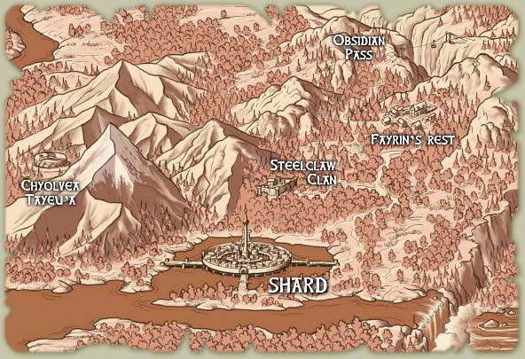
- Official Ilithi rendered map from the Simu web site - Ilithi
- Undergondola & Eleven Fortress, map48: Chyolvea Tayeu’a, Dragon's Spine, Undergondola - updated 12-14
- Fayrin's Rest & The Abyss , map49: The Abyss, Darkmist Moor, South Road & Fayrin's Rest - updated 8-24
- SCC, map50: Steel Claw Clan, Almalne Alolan & Fallow Fields - updated 8-24
- Shard gates, map51: Shard ring roads, Prairie, Remcli Amarcen, Wyvern Trail, Sunbeam Circle, Crystal Shore & Catherine's Court - updated 3-24
- Shard South Bridge & Whistling Woods, map52: Shard South Bridge, Lake of Tears, Whistling Woods, Ice Caves, Gorbesh Fort & Derelict Road - updated 8-24
- Shard, map53: City of Shard - updated 4-20
- Shard Interiors, map54: Shard interiors – Elothean House Consulate, Housing areas, Museum, Theatre, Temples, Trader Plaza & Great Tower - updated 6-17
- Shard Interiors, map55: Shard interiors (cont'd) – Inns & Crafting Society Buildings - updated 3-17
- Shard Elothean Houses, map56: Public areas of each of the Elothean Houses - updated 5-18
- UnderShard, map57: Under the city of Shard - updated 12-14
- Corik's Wall, map58: Corik's Wall, Darkling Woods, Blackthorn Canyon, Lost Grounds & Decrepit Road - updated 12-14
- Western Road, map59: Western Road, Ranger Guild, Crystal Forest & Game Trail - updated 12-14
- Horse Clan, map60: Horse Clan, Gilen Otso Steppes, Prairie Grove, Tanis Belta Gaizen & Julge Dolen Zaldeni - updated 9-18
- Restricted Access areas in Ilithi, IlithiMisc: Guild, Citizen & Elothean House restricted areas in Ilithi. This is a supplemental map to the set and may contain spoilers. - updated 1-15
- Restricted Access areas in Ilithi, IlithiMisc2: Fang Cove - updated 1-15
- Restricted Access areas in Ilithi, IlithiMisc3: Estate Holder restricted areas in Ilithi. This is a supplemental map to the set and may contain spoilers. - updated 6-17
- Ilithi .zip file, IlithiZip: Map48-Map60 & the IlithiMisc supplements - updated 8-24
Forfedhdar Maps (P5)
- Official Forfedhdar rendered map from the Simu web site - Forfedhar
- Western Road, map62: Western Road, Seord Kerwaith, Cragstone Vale - updated 4-10
- Raven's Point, map63: Raven's Point, Seord Kerwaith - updated 4-10
- Haalikshal Highway, map64: Haalikshal Highway, Himineldar Shel, Abandoned Mine - updated 5-10
- Ain Ghazal, map65: Spiral Road, Ain Ghazal, Kradhren Caverns - updated 2-15
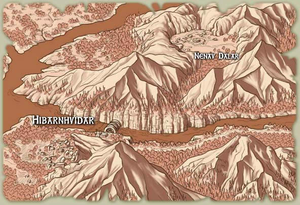
- Outer Hibarnhvidar, map67: Outer Hibarnhvidar - updated 1-15
- Inner Hibarnhvidar, map68: Inner Hibarnhvidar - updated 2-15
- Hibarnhvidar Interiors, map69: Guild Halls, Temple of Kertigen, Taverns - updated 2-15
- Hib. West Gate, map71: Hawstkaal Road, Great Salt Road - updated 2-15
- Boar Clan, map72: Boar Clan, Hawstkaal Road - updated 2-15
- Hunter's Glade, map73: Hunter's Glade, Cleric Guild, Pilgrimage Trail - updated 2-15
- Vela'Tohr areas, map74: Vela'Tohr Edge, Vela'Tohr Woods & Vela'Tohr Overlook, Dark Burrows, Hag's Crag - updated 5-18
- Asketi's Mount, map75: Adders Nest, Temple of the North Wind & Catacombs - updated 5-18
- Restricted Access areas in Forfedhdar, ForMisc01: Estate Holder,Guild, Citizen & Other restricted areas in Forfedhdar. This is a supplemental map to the set and may contain spoilers. - updated 2-15
- Forfedhdar .zip file, ForZip: Map70-Map75 & the ForMisc supplements - updated 5-18
Qi'Reshalia Maps (P4)
- Official Qi'Reshalia rendered map from the Simu web site - Qi'Reshalia
- Lezeni’s Cove, map80: Aesry docks, Lezeni’s Cove, Sea Caves & hunting - updated 3-12
- Shadaer Jama (road to Aesry), map81: Shadaer Jama - updated 3-12
- Aesry Surlaenis'a, map82: city of Aesry and surrounding areas - updated 3-12
- Aesry Surlaenis'a Interiors, map83: Aesry Interiors & Tethloren Island - updated 3-12
- Cliff Trail , map84: Cliff Trail, Meadowlands & Highlands housing, Necropolis - updated 8-22
- Pokekehekepi Beach, map85: Pokekehekepi Beach - updated 12-19
- Costal Road, map86: Ratha Costal Road & Costal Path - updated 12-19
- RTR, map87: Reshalia Trade Route , Tembat Nai Itan & Tzgaa'lakh'adu'gai - updated 12-19
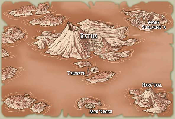
- Ratha 3rd & 4th Tiers, map88: City of Ratha 3rd & 4th (Shh'o'kumu Terrace) Tiers - updated 12-19
- Ratha 1st & 2nd Tiers, map89: City of Ratha 1st & 2nd Tiers - updated 10-19
- Ratha Interiors, map90: Inns, theatre, town hall, Meadow Park & Aldauth's Lair (mining) - updated 10-19
- Ratha Interiors, map91: Guild Halls & Crafting Halls - updated 10-19
- Ratha Sewers, map92: The Ehhrsk Highway (Ratha Sewers) - updated 10-19
- Taisgath & Seerah, map93: Taisgath Island and The Seerah Wreck - updated 3-15
- Hara'jaal, map96: island of Hara'jaal, The Enclave and The Tasia'zaul - updated 12-19
- Mer'Kresh, map97: city of Mer'Kresh & Galleys - updated 12-19
- Mer'Kresh Interiors and Canals, map98: canal hunting areas, interiors - updated 12-19
- Southern M'Riss, map100: Southern M'Riss, Fever Point, Fala Inisharon - updated 9-18
- Northern M'Riss, map101: Northern M'Riss, Dunes of Despair, Penal Colony - updated 12-18
- Restricted Access areas in Qi'Reshalia, QiMisc01: Estate Holder,Guild, Citizen & Other restricted areas on the islands. This is a supplemental map to the set and may contain spoilers. - updated 12-19
- Restricted Access areas in Qi'Reshalia, QiMisc02: Penal Colony. This is a supplemental map to the set and may contain spoilers. - updated 12-18
- Qi'Reshalia .zip file, QiZip: Map80-Map101 & the QiMisc supplements - updated 8-22
Quest and Festival Maps
* In 2025, the festival and quest map section was cleaned up a bit, with reoccuring maps at the top and an archive of other maps below. Additionally, there is now a stable map name for each of the reoccuring events that will be updated as needed and can be bookmarked for use year-after-year.
- Aesthene's Close, MapAC - updated 1-25
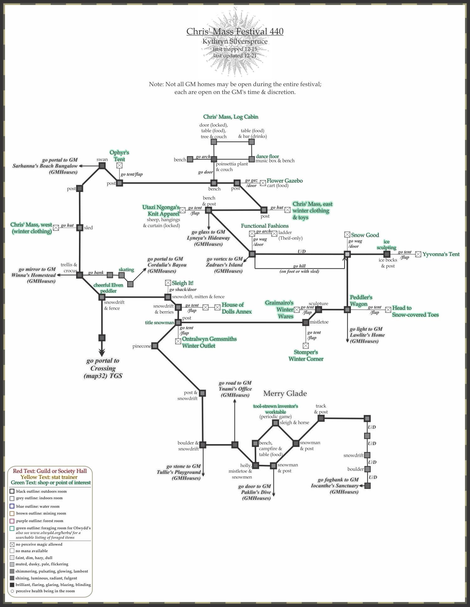
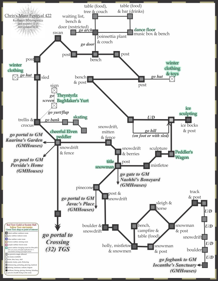
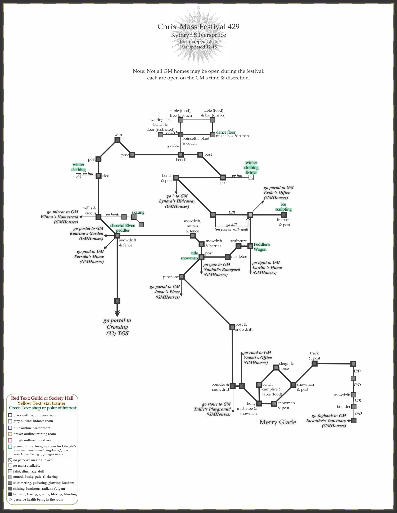
- Chris Mass Festival, MapCM - updated 1-25
- GM Homes - These areas are only open at the discression of the GameMaster's. While they can be found occasionally the rest of the year, during this festival you often will see a number of them with access from the festival grounds. - updated 12/26/23
- Archive:
- Drathrok's Duskruin, MapDD - updated 1-25
- Hollow Eve, MapHE01 - Andreshlew Docks & Lower Island - updated 1-25
- Hollow Eve, MapHE02 - Andreshlew Upper Island - updated 1-25
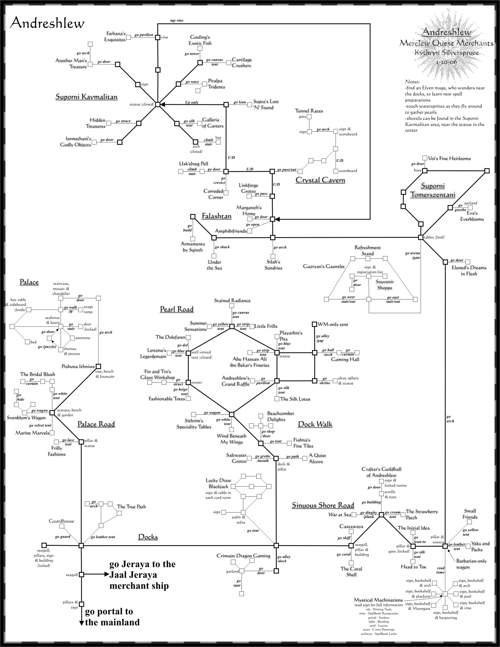
- Andreshlew Docks, Dock Walk, Palace Road & Sinuous Shore Road - updated 11-3-24
- Andreshlew Falashtan, Suporni Tomerszentani & Suporni Kavmalitan - updated 11-3-24
- Archive:
- 2020 Andreshlew Docks, Dock Walk, Palace Road & Sinuous Shore Road
- 2020 Andreshlew Falashtan, Suporni Tomerszentani & Suporni Kavmalitan
- 2021 Andreshlew Docks, Dock Walk, Palace Road & Sinuous Shore Road
- 2021 Andreshlew Falashtan, Suporni Tomerszentani & Suporni Kavmalitan
- 2022 Andreshlew Docks, Dock Walk, Palace Road & Sinuous Shore Road
- 2022 Andreshlew Falashtan, Suporni Tomerszentani & Suporni Kavmalitan
- 2023 Andreshlew Docks, Dock Walk, Palace Road & Sinuous Shore Road
- 2023 Andreshlew Falashtan, Suporni Tomerszentani & Suporni Kavmalitan
- 2024 Andreshlew Docks, Dock Walk, Palace Road & Sinuous Shore Road - updated 11-3-24
- 2024 Andreshlew Falashtan, Suporni Tomerszentani & Suporni Kavmalitan - updated 11-3-24
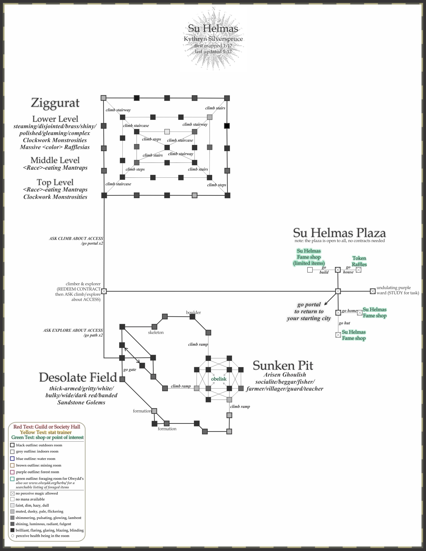
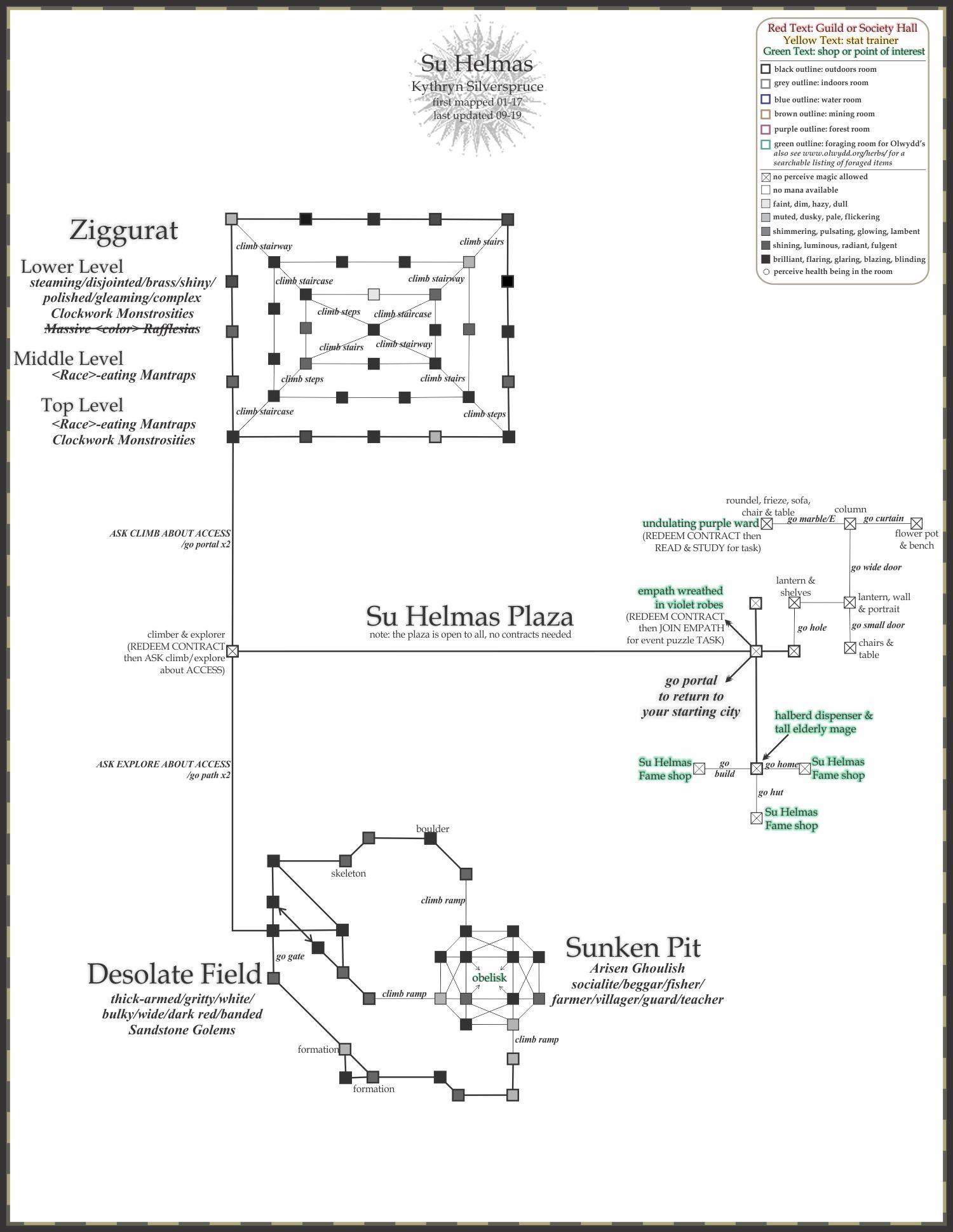
- Su Helmas, MapSH - updated 1-25
- Taisidon Mystery, MapTM01 - Taisidon Island East - updated 10-25
- Taisidon Mystery, MapTM02 - Taisidon Island West - updated 1-25
- Various Maps:
Other Maps
- Aveda's Forfedhdar hunting area maps, (external site link here) - Aveda has focused on the hunting areas, and I want to give them props for not only making some nice maps to use, but the bravery needed to get into some of these places! meep!
- DRService Map Searcher, (external site link here) - Maps that (I believe) have been generated by Ishron with the Genie auto-mapper, however the great thing on this site is that you can plug in room exit directions to filter for rooms that might meet your treasure map criteria. Very handy!
- Ranik's Maps of Elanthia, (external site link here) - Always good to have 2 places to draw information from. Continually updated maps can be found here too!
|
